
A cutting edge geographic information system tool to track the Indian diaspora has been developed by Dr. Tsukasa Mizushima, a professor at Tokyo University. Dr. Mizushima and his colleagues have developed the “India Place Finder“, a web-based application that allows researchers to find geographic information about any place (known as toponym) in India. All places listed in the 2001 Census of India can be found via this tool.
Why is the tool useful to researchers?
Researchers can query a place by either sorting through the list, or narrowing the results by the State, District, or Sub-District. This might sound a lot like Google maps – but it offers more. The tool provides comprehensive topological context to a place, reaching back to 18thcentury India until 2001.
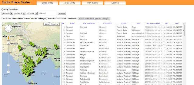
For example, if you search for “Chennai”, the tool shows all matches for Chennai within India, both on a grid (with State, District, Sub-District, Census Code, Latitude, and Longitude) and a map. In addition, all notation fluctuations are also considered and therefore, other places similar to Chennai appear in the results; in this case places like Chenai, Chen and so on also appear on the grid and on the map. Upon zooming into any location, you can find a detailed satellite or topological map.
 |
| Courtesy: India Place Finder (http://india.csis.u-tokyo.ac.jp/) |
So far, 900,000 villages have been included. Researchers can now track relatively obscure places on the maps with exact coordinates, prior to conducting field work. The tool is free to use, and easy to operate. The tool can be used to search one place at a time (Single Mode), or multiple places at a time (CSV Mode).
Information from Census 2001 and 4,500 Survey of India topological maps from 1869 onward have been used to create this vast database. The Government of India restricts the usage of Survey of India maps and the digital framework around Census information. Thus in order to make the map more comprehensive, Dr. Mizushima worked with libraries and with open data sources to develop these maps. For instance, Census 2001 district handbooks were used to map the villages that appear on the tool.
_____________________________________
Dr. Mizushima is currently a professor of South Asian History at the Graduate School of Humanities and Sociology at Tokyo University, and specializes in the Indian geographic and demographic history